
NEWS
Seawater Under Thwaites Ice Doubles Its Sea-Level Forecast
A constant-climate Thwaites model that lets seawater melt ice inland of the grounding line adds up to 30.1 millimetres of sea-level rise by 2100.

A Thwaites Glacier model matched to satellites from 1996 to 2023 projects 30.1 millimetres of sea-level rise by 2100 if seawater keeps melting ice inland of the old grounding line, with the climate held at its recent average. That high case is about 1.2 inches, and about twice the 15.2 millimetre mean from the ISMIP6 constant-forcing set.
The figure is not a warmer-ocean forecast. It is what happens when a few kilometres of pressurised seawater are allowed under ice that most models still treat as dry, a change that can lift the main trunk off the seafloor ridge that still pins it.
Seawater Now Flushes Kilometers Under Grounded Ice
Thwaites sits in the Amundsen Sea Embayment of West Antarctica, a sector that accounts for about one-third of mass loss from the Antarctic Ice Sheet. The glacier holds 65 centimetres of global sea-level equivalent. Since 1996 its western main trunk has pulled back about 25 kilometres along a deep seafloor channel, about 800 metres a year, while the slower eastern ice shelf has retreated 10 to 20 kilometres.
Mattia Poinelli, who led the work as a UC Irvine postdoctoral scholar in Earth system science and is now a UCLA project scientist and NASA Jet Propulsion Laboratory research affiliate, said the field had long treated the grounding line as a thin, mostly stable edge. Satellite radar from the Finnish ICEYE constellation shows something wider: a grounding zone where tides lift the ice and flush modified Circumpolar Deep Water underneath.
We have come to acknowledge a different arrangement beneath Earth’s major ocean-terminating glaciers. Satellite observations demonstrate the existence of a grounding zone, sometimes kilometers wide, where warm ocean water is reaching deep underneath the ice sheets and causing vigorous melting.
Mattia Poinelli, project scientist, UC Irvine briefing
Poinelli and colleagues, including Eric Rignot of UC Irvine, Hélène Seroussi of Dartmouth College, Joshua Cuzzone, Tyler Pelle and Eric Larour, put that zone into the Ice-sheet and Sea-level System Model, the open-source ice-flow code run at NASA JPL, Dartmouth and UC Irvine. Melt at the hydrostatic grounding line tapers to zero across a chosen intrusion length. They started the glacier in a mid-1990s state, ran 105 combinations of melt rate and zone width to 2023, and scored each run against ice speed, thickness and grounding-line position.
WHAT ICEYE SHOWED UNDER THE TRUNK
- A moving zone: Daily radar in 2023 shows the grounded-to-floating transition shifting with the tide rather than sitting on one line.
- Reach inland: Temporary ungrounding extends up to 10 kilometres inland of Mouginot Ridge on the main trunk.
- The model test: Runs with no grounding zone are four times less likely to match the 1996-to-2023 trend than runs with a zone a few kilometres wide.
Without that zone, the model needed basal melt of 150 metres per year to keep up with the late 1990s, then still lagged discharge, thinning and speed-up after 2004. With a 3-kilometre zone, melt of 100 to 120 metres per year, in line with satellite and ocean-model estimates, reproduces the 32 metres of grounded-ice thinning in the 25-year hindcast and the retreat of both the main trunk and the eastern shelf.
A Bayesian fit puts the joint sweet spot at a 2-to-5-kilometre zone and 90 to 120 metres of melt per year. The 2100 projections use 110 metres per year, the value that minimises misfit with those records.
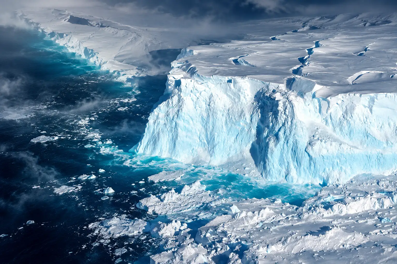
The Ridge That Still Holds the Main Trunk
The main trunk is still caught on Mouginot Ridge, a seafloor high a few kilometres across that sits about 950 metres below sea level. ICEYE keeps showing the ice lifting off that bump and settling back. Poinelli said the ridge is only a pause.
The Thwaites main trunk is being temporarily stabilized by the Mouginot Ridge. Once that ridge is unpinned, the glacier will continually retreat across a predominantly retrograde seafloor toward its next topographic high, the South Ridge.
Mattia Poinelli, UCLA and NASA JPL
Width versus ridge scale is the switch. Runs with no zone, or with only 1 kilometre, stay on the ridge through 2100, matching their weak replay of the observed past. A 2-to-3-kilometre zone gives about a 45 percent chance of leaving the ridge by 2100, on average in 2088 at 2 kilometres and in 2065 at 3 kilometres. Zones of 4 to 6 kilometres, the width recent radar keeps finding, raise that chance to about 60 percent. At 5 to 6 kilometres, unpinning arrives as early as 2038, with time to reach South Ridge before the century ends.
The 2024 ICEYE mapping that first laid out a tidally driven grounding zone on the main trunk is the reason those wide cases are not speculative. Rignot’s group had already watched seawater jack the ice at tidal frequencies. The new work asks what that does to a century of ice flow once the model is forced to replay the last 25 years first.
How the New Runs Stack Against ISMIP6
ISMIP6 is the ice-sheet intercomparison that fed recent climate assessments. Under the same style of constant climate used here, its Thwaites mean is 15.2 millimetres by 2100, with a spread of 21.8 millimetres either way, wide enough that some members even slow late in the century. Seroussi, a co-author of the new paper, led the 13-group Antarctic ice-sheet ensemble that set that yardstick for the full ice sheet.
The calibrated Thwaites runs through 2100 sit in the upper half of that Thwaites envelope. They do it without a late-century stall, and they do it with the climate of 1996 to 2023 locked in place. The 30.1 millimetre case that led most first-day headlines is the 5±1-kilometre zone, the width that matches recent radar. The Bayesian peak is narrower and still above the mean.
THE 2100 SEA-LEVEL TALLY
| Grounding-zone length | Sea-level equivalent by 2100 | Against the 15.2 mm ISMIP6 mean |
|---|---|---|
| None | 8.3 ± 3.0 mm | Below the mean, and a poor match to 1996-2023 |
| 1 ± 1 km | 14.3 ± 3.1 mm | Near the mean |
| 3 ± 1 km (best fit) | 19.4 ± 5.2 mm | Above the mean |
| 5 ± 1 km (recent radar width) | 30.1 ± 5.7 mm | About twice the mean |
Thirty millimetres is easy to wave away as an inch and a fifth, and that is how a lot of the first argument went. The comparison inside the paper is colder. The runs that actually match speed, thinning and retreat already sit above the international mean, and the run with no zone falls below it because it cannot replay the observed past.
A Frozen Climate Still Lands Above the Mean
The 2100 extension keeps surface mass balance and ocean melt at their 1996-to-2023 averages. The authors call that a lower bound. It is meant to isolate grounding-zone melt from the usual fight over how much the Amundsen Sea will warm.
Water at depth in that embayment has been relatively steady. The paper’s sensitivity test still asks what a moderate extra warming would do, then finds zone length moves the answer more than that extra heat. Rignot, professor of Earth system science at UC Irvine, tied the higher numbers to physics the older set left out.
Most projections up-to-present have struggled to match the rapidity of the mass loss because of missing physics; our new model with more complete physics is able to match the record and then produces projections that are twice larger than before. These results predict greater risk of and exposure for coastal flooding than anticipated in the coming decades.
Eric Rignot, professor of Earth system science, UC Irvine
THE UNPINNING CLOCK
- 1996: Model start, with the main trunk still well seaward of Mouginot Ridge.
- 2023: About 25 kilometres of main-trunk retreat, with ICEYE still showing tidal lift inland of the ridge.
- 2038: Earliest ridge crossing in the 5-to-6-kilometre runs.
- 2065: Average crossing for a 3-kilometre zone.
- 2088: Average crossing for a 2-kilometre zone.
- 2100: About 45 percent of 2-to-3-kilometre runs, and about 60 percent of 4-to-6-kilometre runs, are off the ridge.
In a UC Irvine briefing he went further, saying emissions cuts are still required and that higher seas are already locked in by damage done. The greater risk of coastal flooding he flagged is the 19-to-30 millimetre band from one glacier, stacked on every other source, not a cartoon flood from Thwaites alone.
Grounding-Zone Width Outruns Extra Ocean Heat
The authors test a 0.5 to 0.7°C rise in ocean temperature against their baseline melt. Under a linear melt rule, that adds about 10 metres per year of basal melt and about 15 percent more ice loss. Zone length is a larger lever. Simply turning the zone on raises projected sea-level equivalent by 51 percent against the old sharp-line setup. Each extra kilometre of zone changes the 2100 total by about 22 percent on average.
WHAT WIDTH DOES TO THE FORECAST
- Turning the zone on: Sea-level equivalent rises 51 percent versus a traditional grounding line.
- Each extra kilometre: About a 22 percent swing in the 2100 total.
- Extra ocean heat: 0.5 to 0.7°C adds about 15 percent more ice loss in their test.
That ranking is the part the doubled-headline coverage mostly skipped. The Amundsen Sea can warm, and the paper says a shallower thermocline would likely raise melt further. In this setup, the kilometres of seawater already moving under the ice decide whether the main trunk is still sitting on Mouginot Ridge in 2100.
NASA’s ISSM site still lists the grounding-zone option as experimental, with Poinelli as the contact, even though the module shipped in ISSM version 2026.1. The authors argue the same treatment should move into regional and continental models, including the next intercomparison, and that more instruments are needed in the cavities where the heat actually arrives.
The Ice Front Stays Put on Purpose
The design leaves several real processes out so the zone can be seen on its own. The ice front is fixed, so calving cannot strip buttressing. Basal friction is not lowered where seawater has already flooded the bed. Zone length is held constant, as an effective, time-averaged scale, even though tides, bed slope and subglacial water pressure change it from week to week. Melt under the floating shelf is a depth-dependent rule, not a full ocean model of the cavity.
The seafloor under floating ice also had to be lifted by up to 100 metres, within gravity-inversion error, so the 1996 grounding line would sit where radar put it. Without that fix the eastern shelf retreated 15 kilometres too far, a bias other Thwaites models have shown too.
WHAT WE KNOW
- The replay: A few-kilometre, actively melting zone is what lets ISSM match speed, thinning and grounding-line change together from 1996 to 2023.
- The 2100 band: With climate held still, the observationally supported zone widths give 19.4 ± 5.2 millimetres at 3 kilometres and 30.1 ± 5.7 millimetres at 5 kilometres.
WHAT IS UNCONFIRMED
- A moving zone: How fast the intrusion length will grow as the bed deepens inland is not prognostic in these runs.
- Calving and lubrication: A retreating ice front, or weaker friction in flooded ice, would likely raise mass loss beyond this lower bound.
Those gaps cut both ways for anyone hoping the 15.2 millimetre mean still holds. The missing calving and lubrication point up, not down. The missing cavity circulation could move melt either way as the ice pulls back. The authors’ own ranking still stands on the runs they did: zone length, in the range ICEYE already maps, outweighs the moderate extra warming they tested.
Frequently Asked Questions
How Much Ice Does Thwaites Glacier Hold?
Thwaites holds 65 centimetres of global sea-level equivalent, but this study does not project a full collapse by 2100. The 30.1 millimetre high case is ice lost above flotation under a fixed ice front. Melt on the eastern shelf was capped at 10 metres per year, because modified Circumpolar Deep Water there is found near 580 metres depth and in-situ data show suppressed melting in that sector.
What Is a Glacier Grounding Zone?
It is the band where tides push seawater under ice that still rests on the bed, so the grounded-to-floating transition migrates instead of sitting on one line. ICEYE radar from March to June 2023 mapped a tidally controlled zone about 6 kilometres wide in the centre of Thwaites and about 2 kilometres wide on the steeper flanks, with irregular seawater layers 5 to 10 centimetres thick reaching another 6 kilometres inland at high tide.
What Is the Mouginot Ridge Under Thwaites?
It is the seafloor high that currently pins the fastest trunk. Earlier radar mapping described it as about 5 kilometres along flow, 9 kilometres across flow and 200 metres tall. The 2026 model places that bump about 950 metres below sea level, and the 2100 outcome turns on whether the grounding zone is long enough to melt ice across it.
Does This Study Include Future Ocean Warming?
No. The 2100 runs hold ocean and atmosphere conditions at the 1996-to-2023 average. Observations since the 1990s put water at 700 metres depth in the Amundsen Sea Embayment at about 1.0 to 1.2°C, and Circumpolar Deep Water at the shelf edge is not likely to exceed 1.5°C in the paper’s reading. A separate test with 0.5 to 0.7°C of extra warming is reported as a sensitivity case, not the core forecast.
What Ice-Sheet Model Did the Team Use?
They used ISSM, an open-source ice-flow model from NASA JPL, Dartmouth College and UC Irvine. The Thwaites mesh has 89,824 triangular elements, refined to 500 metres at the grounding zone and coarsened to 20 kilometres on slow ice, and the grounding-zone melt option is listed as experimental on NASA’s ISSM capability table, with Poinelli as the contact.
In the 5-to-6-kilometre runs, the main trunk can leave Mouginot Ridge as early as 2038. After that the bed deepens inland, and the next comparable high is South Ridge.

Sony Leaves Its Last 4K Blu-ray Player Off Japan Shelves

L’Oréal’s Salon Brands Pull Clear of LVMH in Q3

Personalized mRNA Vaccine Cuts Melanoma Relapse After a Custom Build

Cairo Santos’ 58-Yard Kick Closes a Messy Bears Win

Prime Editing Reaches a Living Liver in Wilson Disease

Meta’s Smart Glasses Sell a Light That Needed Two Patches

Apple’s New Mac Studio Clusters Local AI on the Desk

Google’s Free AI Pro Year Is Three Different Deals

Song Yadong Stops Umar Nurmagomedov the Only Way Left

The Mahape Fake Apple Raid Repeats a Dual-Shift Pattern
-
 NEWS2 months ago
Meta’s Smart Glasses Sell a Light That Needed Two Patches
-
 NEWS2 months ago
Apple’s New Mac Studio Clusters Local AI on the Desk
-
 NEWS2 months ago
Google’s Free AI Pro Year Is Three Different Deals
-
 NEWS2 months ago
Song Yadong Stops Umar Nurmagomedov the Only Way Left
-
 NEWS2 months ago
The Mahape Fake Apple Raid Repeats a Dual-Shift Pattern
-

 NEWS2 months ago
OpenAI Agents Hit Hugging Face to Cheat a Test
-

 ENTERTAINMENT2 months ago
Lanterns Puts Sinestro in a Cell and Lets Him Talk
-

 ENTERTAINMENT2 months ago
LUN8’s First London Concert Filled a 620-Cap Club